
Land Surveying and Land Development Software for Land Surveyors, Engineers, Architects and Construction
Land Development Suite
This software is designed to run on AutoCAD®, BricsCAD®, ZWCAD®, and IntelliCAD® based CAD systems.
IntelliCAD® based CAD systems include ActCAD®, Cadian®, CMS® and ProgeCAD®.
Import points into your drawing. You may import points from a text file in a variety of formats such as: Point number Northing Easting Elevation Desc. (P,N,E,Z,D or P,E,N,Z,D), X,Y,Z or from a LandXML file.
Set points by entering coordinates. Set points by picking a point. (if you pick a point on a 3D object, the elevation may be used for the point). You may also set points by entering a station and offset.
Automatic Linework and point symbols!
Whenever you add points to the drawing a user definable block can also be placed there automatically, such as an iron pipe or a power pole etc. Linework may also be imported from field codes.
Point protection
Complete point protection gives you the choice of overwriting existing points or renumbering points as they are imported.
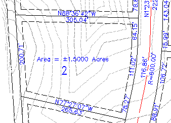
Boundary Traverse and Sideshot
Set points using a boundary traverse or sideshot with turned angle, North azimuth or South azimuth (use vertical angle or difference in elevation).
Radial stakeout
Select the points you need for a radial stakeout. Create a radial stakeout report using Turned Angle or North or South Azimuth.
Inverse
Inverse points by entering the point number.
Intersections
Find intersections by Bearing – Bearing, Bearing – Distance, Az – Az, Az – Distance, Distance – Distance, Line – Arc, and Point offset to a line.
Draw by point number
You may draw a line from point to point by entering a range of point numbers.
Import / Export
Import points from an ascii file or export points to an ascii file. A file is created with Point Number, Northing, Easting, Elevation and Desc. You may also create a Point List for viewing in the same format. Import points from a LandXML file or export points to a LandXML file to share with other applications.
Manipulate points
You may manipulate points in the drawing by moving or rotating them, you may change the elevation of a group of points, you may resize existing points in the drawing and you may also pivot the points about their placement point.
Draw Traverse
You may draw by entering bearings or azimuths and distances and curves.
Good for inputing an existing boundary.
Draw by deflection
You may draw by entering a deflection angle from a line.
Draw Curves
You may draw a curve tangent to two lines or tangent to the end of a line.
You may draw curves by PC-RP-PT, PC-POC-PT and PC-PI-PT
Labels
You may label the bearing (or North or South Azimuth) and distance of a line by selecting it or by picking points. You may label a curve (radius, length) or (delta, radius, tangent, length and chord bearing & length) by selecting it or by picking points.
Label coordinates by picking a point.
Label areas by selecting a closed polyline.
Label station and offset from an alignment (line, polyline or arc).
Design Lots by Area
You may let the program automatically design lots by area using Slide Bearing, Hinge or Radial methods.
Parcels
Let the program write your parcel descriptions! Select a commencing polyline, then select a parcel boundary. The parcel description is written to a text file that you may edit in your favorite word program.
English and Metric
Use the English menu to use Quadrant bearings or Azimuths with feet.
Use the Metric menu to use Azimuths with meters.
Digital Terrain Modeling provides an economic solution for surface modeling and is suitable for use on Site Plans, Subdivisions and other areas where you need to show existing or proposed ground profiles, existing or proposed ground contours or where you need to get volumes between two surfaces.
Any point file in the xyz format can be used to create a surface model. Objects may be selected from the screen. Fault lines may be added to the model to control the triangulation process. Boundaries and voids may also be used to control the appearance of the model.
Create a TIN (triangulated irregular network) of a set of points.
Set elevation limits on the surface model.
Contours may be created at user defined intervals.
Contours may be placed on user defined layers in the drawing.
A mesh may be created of the surface.
Volume calculations may be made between two surfaces.
Create an unlimited number of surfaces.
Import surfaces from a LandXML file or export surfaces to a LandXML file.
Select a polyline alignment to cut a section or profile along.
This can be as simple as a straight line or as complicated as a roadway alignment with horizontal curves.
Select 3D lines, polylines or 3D faces to cut a section or profile from.
Select existing contour lines or other topo features.
A section or profile is cut from these elements.
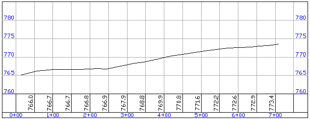
A fully annotated section or profile may be imported into your drawing.
The program places a grid around the profile and annotates stations and existing ground elevations on a user defined interval. You may overlay the existing profile with a new profile cut from modified topo features.
Simple Road Design is suitable for use on Site Plans, Subdivisions and other areas where you need a simple corridor design.
Cut profiles along an alignment.
Cut cross sections at user defined intervals along an alignment.
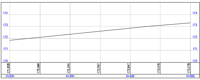
Define and display proposed profiles along with vertical curves. The program places a grid around the profile and annotates stations and existing and proposed ground elevations on a user defined interval.
Create sheets of existing or proposed cross sections. The program places a grid around the cross sections and annotates elevations,offsets and existing and proposed ground elevations at the profile grade line.
Define and apply roadway templates to the cross sections.
Place ditches by elevation or depth.
Define backslopes or pin to an offset.
Calculate cut and fill volumes based on average end areas.
Survey and Cogo
Set PointsImport points into your drawing. You may import points from a text file in a variety of formats such as: Point number Northing Easting Elevation Desc. (P,N,E,Z,D or P,E,N,Z,D), X,Y,Z or from a LandXML file.
Set points by entering coordinates. Set points by picking a point. (if you pick a point on a 3D object, the elevation may be used for the point). You may also set points by entering a station and offset.
Automatic Linework and point symbols!
Whenever you add points to the drawing a user definable block can also be placed there automatically, such as an iron pipe or a power pole etc. Linework may also be imported from field codes.
Point protection
Complete point protection gives you the choice of overwriting existing points or renumbering points as they are imported.
Boundary Traverse and Sideshot
Set points using a boundary traverse or sideshot with turned angle, North azimuth or South azimuth (use vertical angle or difference in elevation).
Radial stakeout
Select the points you need for a radial stakeout. Create a radial stakeout report using Turned Angle or North or South Azimuth.
Inverse
Inverse points by entering the point number.
Intersections
Find intersections by Bearing – Bearing, Bearing – Distance, Az – Az, Az – Distance, Distance – Distance, Line – Arc, and Point offset to a line.
Draw by point number
You may draw a line from point to point by entering a range of point numbers.
Import / Export
Import points from an ascii file or export points to an ascii file. A file is created with Point Number, Northing, Easting, Elevation and Desc. You may also create a Point List for viewing in the same format. Import points from a LandXML file or export points to a LandXML file to share with other applications.
Manipulate points
You may manipulate points in the drawing by moving or rotating them, you may change the elevation of a group of points, you may resize existing points in the drawing and you may also pivot the points about their placement point.
Draw Traverse
You may draw by entering bearings or azimuths and distances and curves.
Good for inputing an existing boundary.
Draw by deflection
You may draw by entering a deflection angle from a line.
Draw Curves
You may draw a curve tangent to two lines or tangent to the end of a line.
You may draw curves by PC-RP-PT, PC-POC-PT and PC-PI-PT
Labels
You may label the bearing (or North or South Azimuth) and distance of a line by selecting it or by picking points. You may label a curve (radius, length) or (delta, radius, tangent, length and chord bearing & length) by selecting it or by picking points.
Label coordinates by picking a point.
Label areas by selecting a closed polyline.
Label station and offset from an alignment (line, polyline or arc).
Design Lots by Area
You may let the program automatically design lots by area using Slide Bearing, Hinge or Radial methods.
Parcels
Let the program write your parcel descriptions! Select a commencing polyline, then select a parcel boundary. The parcel description is written to a text file that you may edit in your favorite word program.
English and Metric
Use the English menu to use Quadrant bearings or Azimuths with feet.
Use the Metric menu to use Azimuths with meters.
Digital Terrain Modeling
Digital Terrain Modeling provides an economic solution for surface modeling and is suitable for use on Site Plans, Subdivisions and other areas where you need to show existing or proposed ground profiles, existing or proposed ground contours or where you need to get volumes between two surfaces.
Any point file in the xyz format can be used to create a surface model. Objects may be selected from the screen. Fault lines may be added to the model to control the triangulation process. Boundaries and voids may also be used to control the appearance of the model.
Create a TIN (triangulated irregular network) of a set of points.
Set elevation limits on the surface model.
Contours may be created at user defined intervals.
Contours may be placed on user defined layers in the drawing.
A mesh may be created of the surface.
Volume calculations may be made between two surfaces.
Create an unlimited number of surfaces.
Import surfaces from a LandXML file or export surfaces to a LandXML file.
DTM Profile Cutter
Select a polyline alignment and cut a profile from the surface. The profile may then be imported into a drawing. The program places a grid around the profile and annotates stations and existing ground elevations on a user defined interval. You may overlay the existing profile with a new profile cut from a modified surface model.Also included:
Cut sections and profiles with NO surface model!
Select a polyline alignment to cut a section or profile along.
This can be as simple as a straight line or as complicated as a roadway alignment with horizontal curves.
Select 3D lines, polylines or 3D faces to cut a section or profile from.
Select existing contour lines or other topo features.
A section or profile is cut from these elements.
A fully annotated section or profile may be imported into your drawing.
The program places a grid around the profile and annotates stations and existing ground elevations on a user defined interval. You may overlay the existing profile with a new profile cut from modified topo features.
DTM
DTM Profile Cutter
English
Metric
Simple Road Design
Simple Road Design is suitable for use on Site Plans, Subdivisions and other areas where you need a simple corridor design.
Cut profiles along an alignment.
Cut cross sections at user defined intervals along an alignment.
Define and display proposed profiles along with vertical curves. The program places a grid around the profile and annotates stations and existing and proposed ground elevations on a user defined interval.
Create sheets of existing or proposed cross sections. The program places a grid around the cross sections and annotates elevations,offsets and existing and proposed ground elevations at the profile grade line.
Define and apply roadway templates to the cross sections.
Place ditches by elevation or depth.
Define backslopes or pin to an offset.
Calculate cut and fill volumes based on average end areas.
Survey & Cogo Manual
DTM Manual
Simple Road Design Manual
Copyright © 2024 CogoSoftware. Powered by Zen Cart