
Land Surveying and Land Development Software for Land Surveyors, Engineers, Architects and Construction
Point Traverse and Line Label Tutorial
THIS IS A TUTORIAL TO SET POINTS BY TRAVERSING AND
THIS IS A TUTORIAL FOR LABELING LINES.
1) THE FIRST THING THAT WE WILL DO IS TO SET THE DRAWING SETTINGS:
Start a new drawing.
Here is a copy of the finished drawing that you may download: Drawing
From the pull down menu go to:
Drafting-)Drawing setup
Select units English or Metric: (E or M) M
Enter ratio of drawing 1: 250
Text size has been set to 3mm
Lets get the drawing zoomed correct so we can see the points come in.
Draw a circle with the center at 500,500 and a radius of 200.
Now zoom extents (the circle should now fill the screen).
Erase the circle.
Save the drawing.
Command: circle
2Point/3Point/RadTanTan/Arc/Multiple/(Center of circle): 500,500
Diameter/(Radius): 200
Command: zoom
Zoom: In/Out/All/Center/Extents/Left/Previous/Right/Window/(Scale (nX/nXP)): E
Command: erase
Select entities to delete: Select the circle
Entities in set: 1
Select entities to delete: Press Enter
Command: Save
2) NEXT WE WILL SET A STARTING POINT BY COORDINATE:
From the pull down menu go to:
DPpoints-)Set pnts by coords
Point number: (1) Press Enter
Northing: 500
Easting: 500
Elevation: (0.000)100
Description (): base
Point number: (2)
Now press Enter twice to cancel this command.
NOTE: You can end most commands by hitting Enter (a null response).
Review: We have just set a point by coordinates at E=500.000, N=500.000, Elev=100.000 with a description of "base".
3) NOW WE WILL SET POINTS BY TRAVERSING USING NORTH AZIMUTH
We will be traversing using difference in elevation and the rod height will be set to 5.000
For this exercise we will also assume that the instrument is set at 5.000 above the point.
From the pull down menu go to:
DPpoints-)Traverse/Sideshot: North Azimuth-)Diff in Elev
Enter point number to set on: (Press enter to pick a random point) 1
Enter occupied point elevation: (100.000) Press Enter to accept
Enter instrument height above point: (0) 5
Total HI is 105.000
Enter North azimuth: (dd.mmss) 10.1530 (note the Azimuth is: 10 degrees 15 minutes 30 seconds)
Enter horizontal distance: 150.000
Enter rod height: (0.000) 5
Enter difference in elevation: (0) 1
Point number: (2) Press Enter
Description (): trav (Note: Use the description that you wish.)
Enter North azimuth: (dd.mmss) If we want we can enter more points. We want to move forward so press Enter.
Setting on point No.2 E= 526.713 N= 647.602 Elev= 101.000
Do you wish to continue? Y/N (N): Y
Enter occupied point elevation: (101.000) Press Enter to accept
Enter instrument height above point: (0) 5
Total HI is 106.000
Enter North azimuth: (dd.mmss) 45.2515
Enter horizontal distance: 75.000
Enter rod height: (0.000) 5
Enter difference in elevation: (0) 1
Point number: (3) Press Enter
Description (): trav
Enter North azimuth: (dd.mmss) We want to move forward so press Enter.
Setting on point No.3 E= 580.134 N= 700.244 Elev= 102.000
Do you wish to continue? Y/N (N): Y
Enter occupied point elevation: (102.000) Press Enter to accept
Enter instrument height above point: (0) 5
Total HI is 107.000
Enter North azimuth: (dd.mmss) 135.1725
Enter horizontal distance: 100.000
Enter rod height: (0.000) 5
Enter difference in elevation: (0) -2
Point number: (4) Press Enter
Description (): trav
Enter North azimuth: (dd.mmss) We want to move forward so press Enter.
Setting on point No.4 E= 650.486 N= 629.176 Elev= 100.000
Do you wish to continue? Y/N (N): Y
Enter occupied point elevation: (100.000) Press Enter to accept
Enter instrument height above point: (0) 5
Total HI is 105.000
Enter North azimuth: (dd.mmss) 180.0000
Enter horizontal distance: 100.000
Enter rod height: (0.000) 5
Enter difference in elevation: (0) -0.5
Point number: (5) Press Enter
Description (): trav
Enter North azimuth: (dd.mmss) We want to move forward so press Enter.
Setting on point No.5 E= 650.486 N= 529.176 Elev= 99.500
Do you wish to continue? Y/N (N): Y
Enter occupied point elevation: (99.500) Press Enter to accept
Enter instrument height above point: (0) 5
Total HI is 104.500
Enter North azimuth: (dd.mmss) 225.3026
Enter horizontal distance: 50.000
Enter rod height: (0.000) 5
Enter difference in elevation: (0) 0.3
Point number: (6) Press Enter
Description (): trav
Enter North azimuth: (dd.mmss) We want END so press Enter.
Setting on point No.6 E= 614.819 N= 494.135 Elev= 99.800
Do you wish to continue? Y/N (N): N
Be sure to save your drawing often!
4) NOW WE WANT TO DRAW LINES TO CONNECT OUR TRAVERSE:
From the pull down menu go to:
DPpoints-)Draw by Point No.
Separate point numbers with a comma or use hyphen for range.
Enter range of point numbers: 1-6,1
5) NOW WE WANT TO LABEL THE AZIMUTH AND LENGTH OF EACH LINE:
We will select the option to label both the Azimuth and Length on top of the line.
From the pull down menu go to:
Labels-)Label lines AZN-)Azn Dist /
SELECT EACH LINE
(Select the line toward the end of the line that you are starting from.
If you select the line toward the other end the Azimuth will be reversed.)
Select line to label: Select the first line toward the beginning.
Select line to label: Select the next line.
Select line to label: Select the next line.
Select line to label: Select the next line.
Select line to label: Select the next line.
Select line to label: Select the next line.
Select line to label: Press Enter to End.
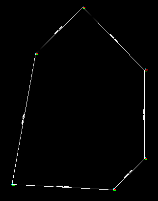
Be sure to save your drawing often!
Your drawing should look like this:
6) NOW LETS PRINT OUT A TRAVERSE AND CLOSURE REPORT:
Labels-)Closure report-)Azimuth North
Select beginning point: Select the end point of the beginning line.
Select traverse lines and arcs in order: Now select each line (or arc) in a clockwise direction.
Select entities: Select line.
Entities in set: 1
Select entities: Select line.
Entities in set: 2
Select entities: Select line.
Entities in set: 3
Select entities: Select line.
Entities in set: 4
Select entities: Select line.
Entities in set: 5
Select entities: Select line.
Entities in set: 6
Select entities: Press Enter
Total length = 589.968
Total area = 22771.202
The report will be displayed in Notepad. You may print it out.
HERE IS THE REPORT:
TRAVERSE AND CLOSURE REPORT
-------------------------------------------------
Line:
Beginning at N = 500.000, E = 500.000
Ending at N = 647.602, E = 526.713
10d15'30" Length = 150.000m
Line:
Beginning at N = 647.602, E = 526.713
Ending at N = 700.244, E = 580.134
45d25'15" Length = 75.000m
Line:
Beginning at N = 700.244, E = 580.134
Ending at N = 629.176, E = 650.486
135d17'25" Length = 100.000m
Line:
Beginning at N = 629.176, E = 650.486
Ending at N = 529.176, E = 650.486
180d00'00" Length = 100.000m
Line:
Beginning at N = 529.176, E = 650.486
Ending at N = 494.135, E = 614.819
225d30'26" Length = 50.000m
Line:
Beginning at N = 494.135, E = 614.819
Ending at N = 500.000, E = 500.000
272d55'26" Length = 114.968m
Boundary is closed. (If the boundary did not close an error of closure would be printed here)
Total length = 589.9684m
Total area = 22771.202 Sq.Meters
Total area = 2.277 Hectares
Copyright © 2024 CogoSoftware. Powered by Zen Cart